Introduction
Have you ever thought of locating yourself on the blue planet (Earth)? This might be a tough question if you are residing in a new place.
But don’t worry, the answer is simple, the GPS. GPS is a tiny device used as a navigation receiver in ships, and aviator, smartphones and many more.
In this tutorial, you will know the working and applications of GPS employed in various fields. We will start with basics of GPS and elements of a navigation system.
What is GPS?
GPS is a tiny device used as a navigation receiver in ships, and aviator, smartphones and many more. It offers the position, navigation, and timing details in the space.
GPS is the abbreviated form of Global Positioning System introduced by the Department of Defense (United States) for the military crew. This satellite navigation system is named NAVSTAR (Navigational Satellite Timing and Ranging).
Later, GPS receivers have been developed to find out the accurate position of a particular location and in weather navigation applications.
The GPS system consists of 30 satellites placed 20,000 Km above the earth in various orbits, commonly called GPS constellation.
These satellites revolve around the earth for every 12 hours periodically. They will keep track of worldwide position, velocity and time.
GPS satellite broadcast the information (Date, time, position, and astronomical data) related to all the satellites in the constellation.
The GPS satellites in the space are designed in such a way that receivers capture the information 4 satellites at any time. It gets the calculated distance from the satellite. In order to receive the GPS signals, the sky has to be unclouded.
Each satellite transmits low power RF signals with unique range codes (Coarse/Acquisition code and Precision code). Coarse/Acquisition code is free for every user but the precision code is restricted for military purpose.
Satellites transmit at two frequencies, 1.57542 GHz, and 1.2276 GHz. GPS also known as Global Navigation Satellite System (GNSS) is not a single subsystem and it is divided into 3 main components. They are Space Segment, Control Segment, and User Segment.
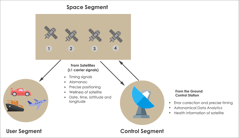
Space Segment consists of Satellites rotating around the earth and passing information (latitude, longitude, and altitude) to the GPS receivers. Moreover, it determines the UTC (Universal Coordinated Time).
Control Segment
This unit supervises the status of satellite and sends back the error and rectification data. The data is corrected and send back to the satellite.
User Segment comprises the GPS receivers that collect the satellite information.
There are numerous satellites in the space developed by many countries. Some of them are GLONASS (Russia), IRNSS (India), BDS (China), and Galileo (Europe).
How does GPS work?
The GNSS satellite works by the following principle. Satellites are built with high precision atomic clocks operating at a frequency of 10.23 MHz. These clocks help in calculating the position and location of the receiver.
The crystal oscillator used in a satellite is the most important element in determining the almanac data.
The accuracy of a crystal oscillator is measured in terms of PPM (Parts per Million). Generally, the ppm used in the satellite is in the order of 1ppm. This ppm varies with the temperature and responsible for shifting of frequency. Hence it is necessary to design and use accurate crystal.
The errors may occur not only due to clock stability. It may happen due to ionosphere and troposphere delays, a number of visible satellites, and receiver clock timing.
The GPS satellite generates two carrier frequencies (L1 and L2) located in L-band. L1 carrier is transmitted at a frequency of 1575.42 MHz and L2 carrier wave at 1227.60 MHz’.
These carrier waves are modulated with C/A code and P-code. This modulated wave is called radio wave.
Now the distance is equal to the time taken for the radio wave to travel from the satellite to the GPS receiver multiplied by the speed of the radio wave.
Distance = Speed of Radio wave X Travelling time of the radio wave
The GPS uses the dead reckoning principle to calculate the current position based on previously obtained position. This is technically named as GPS fix.
As I said, there are nearly 30 satellites in the space, you might think, how many satellites are needed to cover the earth?
The answer is, to locate yourself minimum 3 satellites are sufficient. But to determine accurate location and position, at least 4 satellites are required.
The 4 satellites communicate with each other and give the nearest position with centimeter-level accuracy.
What is 1PPS and Leap Second in GPS?
Here is the important concept to understand the working of GPS. Gps receivers and radio beacons output 1PPS (Pulse per Second) to fix the GPS for the first time.
This timing pulse is so accurate generating exactly one pulse per second.
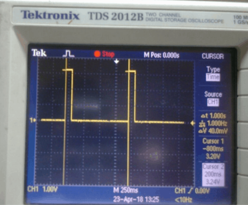
In practical, the below screenshot shows the 1PPS signal generated from the GPS receiver.
The delay between two pulses is one second. The pulse width of 1PPS is 100ms. The pulse width varies based on the GPS configuration.
Leap Second in GPS refers to the correctness of the solar mean time (GMT). This means the earth slows down its rotation leading to the difference between UTC (Greenwich Mean Time) and GPS time.
To compensate this leap second is added to UTC time (Universal Coordinated Time).
Hence GPS time = UTC time + Leap second from the GPS satellite
Now currently, the Leap second is 18 seconds.
The GPS receivers get leap second factor from the satellite and add it to the UTC time.
Applications of GPS
GPS has been used in many areas of industry for serving mankind. Some of the GPS applications are:
- Fault measurement of Earthquakes.
- To eradicate the terrorism activities.
- Weather based data acquisition device uses GPS to track the date, time, latitude and longitude.
- Ground navigation robots for determining the latitude, longitude, speed and time in military applications.
- In automotive cars, bikes and aerial vehicles
- Farmers make use of GPS for seasonal tracking of field mapping, soil evaluation, and yield analysis.
- Used in space and astronomical fields.
- GPS trackers for luggage.
- In the marine industry for shipping navigation.
- Radiosonde or High Altitude Weather balloons use GPS for measuring vertical profiles of the atmospheric temperature, humidity, and pressure and wind parameters.
- Heavy machine navigation.
GPS receivers locate, communicate and accelerate the current industry requirements.
Conclusion
Right from our smartphones to high-speed aerial vehicles (drones) make use of GPS for tracking and locating of unknown places. This revolutionized technology is implemented in the Internet of Things, and wearable embedded systems etc.
Suggested references